
Apart from a few crumbling concrete structures, the tranquil Normandy coastline gives little indication of the huge battle that waged between Allied forces and German troops nearly 70 years ago. The barbed wire, anti-tank obstacles and machine gun placements have all but gone.
Go deeper with GlobalData

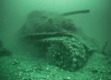
But it is a different story off the Normandy coast. Ghostly remains of ships, landing crafts and even tanks lie on the sea floor untouched since 1944. They serve as a haunting reminder of the biggest seaborne invasion in history and the subsequent struggle to liberate Europe from Nazi rule.
This year, specialists from different fields came together to locate these wreckages and create a definitive map for future generations. The expedition lasted six weeks and mapped approximately 500km2 of Normandy coast with state-of-the-art sonar equipment. The result is the largest and most-detailed archaeological offshore map of the D-Day beaches ever created.
This historic expedition will also be the subject of a major television series to be broadcast next year to commemorate the 70th anniversary.
Organisers split the expedition into two phases, the first lasting four weeks and the second lasting two weeks. Crews worked 24 hours a day in order to reveal never-before-seen images of the sea bed with many sunken vessels remaining intact despite being battered by the sea for 70 years.
How well do you really know your competitors?
Access the most comprehensive Company Profiles on the market, powered by GlobalData. Save hours of research. Gain competitive edge.

Thank you!
Your download email will arrive shortly
Not ready to buy yet? Download a free sample
We are confident about the unique quality of our Company Profiles. However, we want you to make the most beneficial decision for your business, so we offer a free sample that you can download by submitting the below form
By GlobalDataOne of the key participants in the project was the UK Hydrographic Office (UKHO), which is a part of the UK Ministry of Defence. The UKHO has already mapped an area of Normandy in 2011 and returned this year to assist on the mammoth project.
Grant Turnbull: How did the UK Hydrographic become involved in the project?
Chris Howlett: The project was started two years ago by Sylvain Pascaud, who is a French TV producer. With the 70th anniversary of D-Day coming up next year he had this vision of draining the water out of the Bay of Seine and therefore exposing the undersea topography including the wrecks and telling the story of D-Day through the archaeology of the sea floor.
He was going around gathering support, he’s not a surveyor, he recognises that he’s a coordinator, and he was looking for survey expertise to bring it all together. He’d heard of the UKHO and our D-Day survey which we did in 2011 and therefore he contacted us to see if we would be interested in going back there to join in with this larger survey.
GT: How will the wreckage information be used?
CH: The information that was gathered is going to be used to make an underwater map to identify and indicate the locations of all the wreckages which are in the Normandy area. Not all of it has previously been able to be identified. Certainly we have records of wrecks and when we went over them there was nothing there. The intention is to show where all the wreckages are, they are trying to tell the story of not just D-Day as the assault, as the battle for the beach, but the massive follow-up operation which kept the troops ashore supplied with everything they needed.
GT: Did you find a lot of wreckage from the actual D-Day landings?
CH: To be honest, there’s not all that much from the day of the assault because not a huge number of ships sank on D-Day. There’s probably about 10 or 15 ships that were actually sunk on D-Day, a lot of landing crafts were damaged but they tended to get damaged on the beach and were therefore salvaged.
But there are probably 100 or so vessels that were sunk in the follow-up phase from mines and bombs that the German’s had managed to get into the area.
GT: Will this information be used by the UKHO?
CH: Funnily enough no, it may find its way onto our charts but it would have to go to the French Hydrographic Office. They would put it onto their charts and then we would put it onto our charts. We don’t chart French waters from scratch, that would be up to the French. With the data we collected in 2011 we sent it to the French Hydrographic Office who may or may not choose to update the charts depending on what they find.
GT: What is the importance of a project like this?
CH: I think the importance of the whole project is the archaeological record of the size of the battle, not just D-Day itself but the battle to conquer Europe, Normandy and the area. On land, all the wreckage has been cleared away, you still have the concrete bunkers that give us some form of evidence but actual evidence of the battle is gone.
Underwater, although a number of wreckages have been salvaged or a number of them blown up so they are no longer a danger to surface shipping, they are still there as evidence of the struggle that went on and over time – and its coming up to 70 years, they are made of metal and in a high-energy tidal area – these things are disintegrating so in another 70 years there will be a lot less than there is now.
GT: What happened during the first phase of the expedition?
CH: They were running 24 hours a day, they would come in every four or five days to get more food and water, provisions and stuff on board but between those they were running long lines up and down the Normandy coast covering the area with a wide-angle sonar called an EdgeTech 4600. In the first stage there was only one vessel – Etoile Marine’s Magic Star – a catamaran yacht which was quite slow.
The Normandy area is 50 miles long and it was going at about 5 knots, so that’s 10 hours to get from one end to the other. You would get two lines per day, one up and one back in your 24 hours. They go up one line, they move over 50 or 100 metres and they come back and then they move over another 50 and 100 metres and go back again and that was maintained for 24 hours a day for around four weeks.
GT: How was the second phase different?
CH: In the second phase, we had a second boat that joined us and that was a ship called the Andre Malraux, which is a French government ship.
It carried two manned submarines and often we would meet up with this and the submarines would go down with the film crews.
We were going back to visit targets that had been found in the first phase and then we covered them with the high definition sonar to get better images.
Partly the intention was to identify what it was via the high definition images or if we knew what it was it was to get decent images of it. In the second phase we also had divers and the submarines which would go down and film the wrecks which would be used in the TV programmes.
We also had veterans that were brought over on the boat and were interviewed by the TV people about their experiences, often whilst above the wreck of the vessel that they had served on.
A couple of the more adventurous veterans even got on-board the submarines and went down. I’m jealous because I didn’t quite get on a submarine because of the poor weather.
GT: How does the sonar technology work?
CH: When I was onboard we only used the R2 Sonic 2024, which is a very modern sonar. It’s a multi-beam sonar so it puts down a swath of sound that is narrow fore and aft to the ship but wide across the ship’s track. The sonar will ping, it will do about 50 pings a second as you move forward and you get about 250 depths across that ping and basically that gives you enough information and detail to see what’s down there.
The EdgeTech 4600 is a slightly different technology, it’s called an interferrometric multi beam or interferrometric side scan. And it gives the same sort of picture but at a much lower resolution and much wider swath. The swath from the interferrometric sonar is five or six times as wide as the high definition sonar’s swath which allows you to cover a lot more area a lot more quickly.
As is often the case, there is a trade off, and, you can have a wide swath or you can have high detail but the laws of physics seem to dictate that you can’t get them both.
GT: What is it like seeing a wreck for the first time?
CH: It’s interesting because the sonar gives you a real-time display of what you’re seeing and you are kind of painting this picture. The Normandy coast is featureless and barren when there is no wreck there so you have this flat sea floor, and as you approach the wreck you could obviously see the thing because they covered it on the earlier phase, so you know you’re getting to it. And generally speaking people would stop what they are doing and gather around waiting to see what would appear on the screen.
.gif)