The aerospace and defense industry continues to be a hotbed of patent innovation. Activity is driven by the pressing need for modernization, and the growing importance of technologies such as artificial intelligence (AI), Internet of Things (IoT), and unmanned systems. In the last three years alone, there have been over 237,000 patents filed and granted in the aerospace and defense industry, according to GlobalData’s report on Internet of Things in defense: georeferencing. Buy the report here.
Smarter leaders trust GlobalData

However, not all innovations are equal and nor do they follow a constant upward trend. Instead, their evolution takes the form of an S-shaped curve that reflects their typical lifecycle from early emergence to accelerating adoption, before finally stabilizing and reaching maturity.
Identifying where a particular innovation is on this journey, especially those that are in the emerging and accelerating stages, is essential for understanding their current level of adoption and the likely future trajectory and impact they will have.
110 innovations will shape the aerospace and defense industry
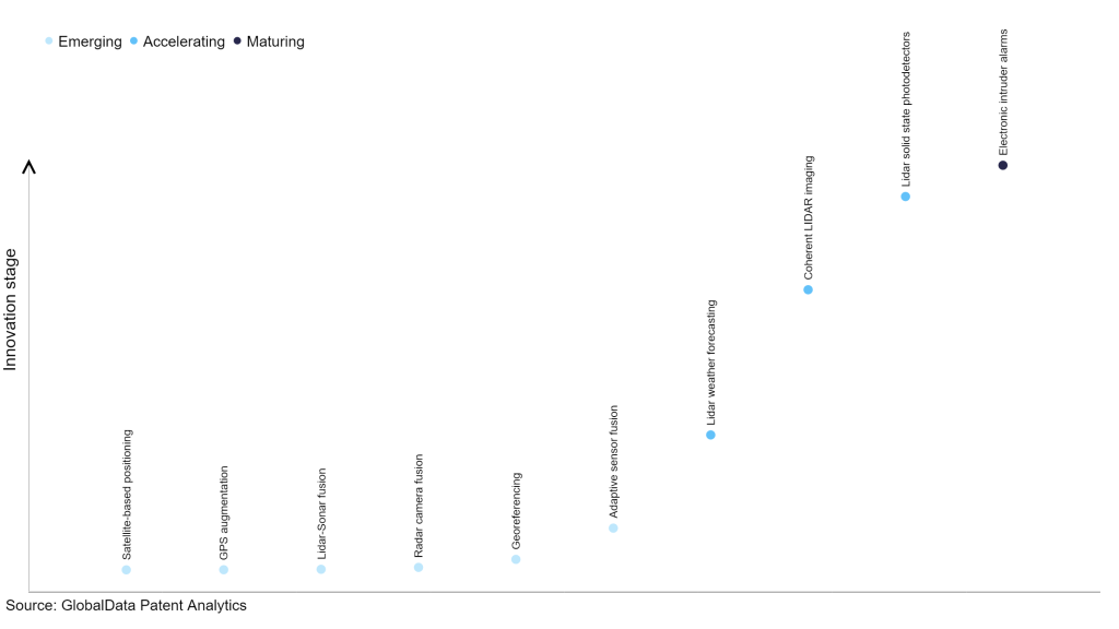
According to GlobalData’s Technology Foresights, which plots the S-curve for the aerospace and defense industry using innovation intensity models built on over 206,000 patents, there are 110 innovation areas that will shape the future of the industry.
Within the emerging innovation stage, satellite-based positioning, GPS augmentation, and LiDAR-sonar fusion are disruptive technologies that are in the early stages of application and should be tracked closely. LiDAR weather forecasting, coherent LiDAR imaging, and LiDAR solid state photodetectors are some of the accelerating innovation areas, where adoption has been steadily increasing.
Innovation S-curve for Internet of Things in the aerospace and defense industry
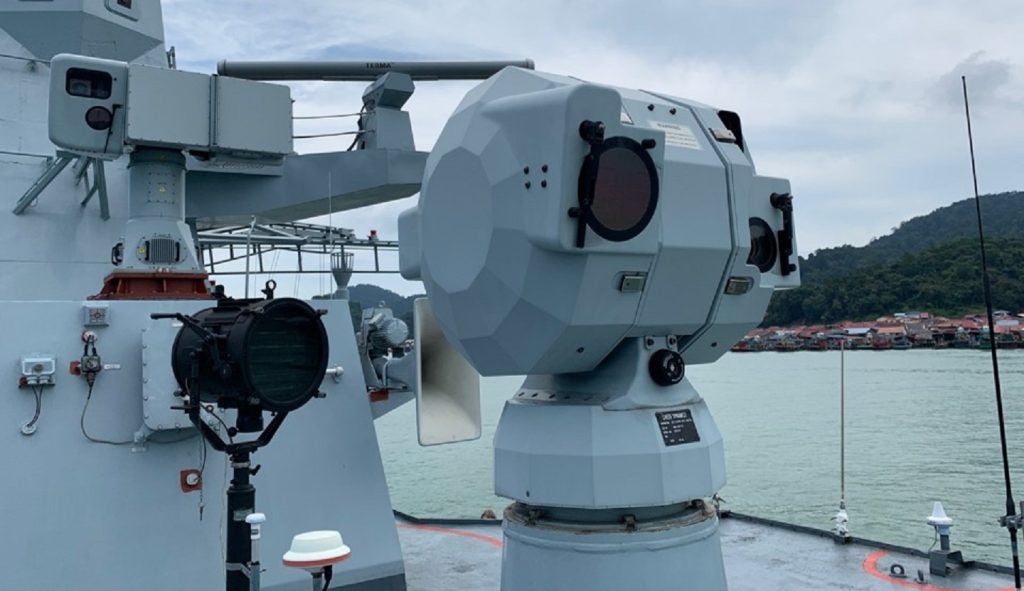
Georeferencing is a key innovation area in Internet of Things
Georeferencing is a process of assigning geographic information to data, images or maps. It helps in making the data or image usable and visible in a geographic context. In these patents, georeferencing is used in assessing damage to infrastructure, determining physical structure conditions, analyzing image data for property damage, and monitoring crop health and stress.
GlobalData’s analysis also uncovers the companies at the forefront of each innovation area and assesses the potential reach and impact of their patenting activity across different applications and geographies. According to GlobalData, there are 420+ companies, spanning technology vendors, established aerospace and defense companies, and up-and-coming start-ups engaged in the development and application of georeferencing.
Key players in georeferencing – a disruptive innovation in the aerospace and defense industry
‘Application diversity’ measures the number of applications identified for each patent. It broadly splits companies into either ‘niche’ or ‘diversified’ innovators.
‘Geographic reach’ refers to the number of countries each patent is registered in. It reflects the breadth of geographic application intended, ranging from ‘global’ to ‘local’.
Patent volumes related to georeferencing
Source: GlobalData Patent Analytics
Boeing is one of the leading patent filers in georeferencing. It filed patents related to methods and systems of determining the absolute geographical position of target object points from images and associated camera positions, collecting the terrain source data covering the area along a predefined mission route and automatically generating a terrain model for display during a simulated flight, and geographically registering a perspective image of a location and geocoding the image with precise geographic location and elevation data.
The company’s Class-3 electronic flight bag (EFB) system provides enhanced situational awareness to pilots by integrating onboard georeferencing technology with Jeppesen electronic airport taxi maps.
The ScanEagle unmanned aerial vehicle (UAV), designed and manufactured by Boeing subsidiary Insitu, is equipped with a high-accuracy photogrammetric (HAP) payload, which can be integrated with a geographic information system (GIS) to provide instant, high-quality georeferenced spatial data, informing critical mission decisions.
Some other key patent filers in the georeferencing space include Raytheon Technologies, Thales, and Airbus.
In terms of application diversity, Skydio, BAE Systems, and Boeing are some of the leading innovators. By means of geographic reach, some of the leading patent filers include Israel Aerospace Industries, Airbus, and Thales.
To further understand the key themes and technologies disrupting the aerospace and defense industry, access GlobalData’s latest thematic research report on Aerospace & Defense.
Data Insights
From
![]()
The gold standard of business intelligence.
Blending expert knowledge with cutting-edge technology, GlobalData’s unrivalled proprietary data will enable you to decode what’s happening in your market. You can make better informed decisions and gain a future-proof advantage over your competitors.
GlobalData, the leading provider of industry intelligence, provided the underlying data, research, and analysis used to produce this article.
GlobalData’s Patent Analytics tracks patent filings and grants from official offices around the world. Textual analysis and official patent classifications are used to group patents into key thematic areas and link them to specific companies across the world’s largest industries.