
The search for missing flight MH370 has seen a mammoth international effort between 26 governments and an unprecedented use of military technology in the air, on land, at sea and in space. According to the latest statement from Malaysia’s Prime Minister, the plane most likely came down in the southern Indian Ocean with a loss of all passengers and crew.
Go deeper with GlobalData

Discover B2B Marketing That Performs
Combine business intelligence and editorial excellence to reach engaged professionals across 36 leading media platforms.
At one point, the search area for the missing airliner spanned an enormous 2.97 million sq miles – an area approximately the size of the US. Searches were focused on two arcs, one southern and one northern, after satellite data revealed the aircraft had sent out signals up to six hours after it dropped off Malaysian radar screens.
With huge expanses of ocean and land to search, along with treacherous conditions in the southern Indian Ocean, the military has so far been the best equipped to lead the search efforts. Here we look at some of the military equipment deployed during the search and why it has been best suited for the job.
Maritime Patrol Aircraft
Since day one, navies from across Southeast Asia have deployed maritime aircraft in order to find the aircraft and any possible survivors. Malaysia and Vietnam both sent out search aircraft in the initial phases to scour the Gulf of Thailand, where it was initially thought the aircraft went down.
A US Navy P-3 Orion Maritime Patrol Aircraft (MPA), full of advanced sensors and electronics, soon joined the search.
The tragic disappearance of a Malaysian airliner on Saturday has brought together opposition navies in a rare show of maritime cooperation in the waters of Southeast Asia.
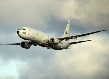
As new information revealed the aircraft had possibly flown in a northern arc towards Central Asia or southern arc deep into the Indian Ocean, more MPAs took to the skies in a bid to find the missing jet. The US Navy has been using one of its newest and most advanced assets, the P-8 Poseidon, which only began flying operational missions last year.
The P-8 Poseidon is kitted out with infrared and night-vision sensors, on-board radar to detect ships and small vessels and an advanced magnetic anomaly detection (MAD) system which can detect submarines underwater. While not being able to actually recover wreckage, aircraft like this can cover huge areas and direct ships in the area to possible crash sites.
As focus has shifted to the southern arc, a number of Royal Australian Air Force P-3 Orion aircraft have flown sorties over areas identified as possible debris locations. On Monday, two Chinese IL-76 aircraft which recently joined the search said they spotted "suspicious objects" in the water.

Communication and imagery satellites
Many of the developments we’ve witnessed over the last three weeks have only been possible through the use of satellite technology. It might be fair to say that if satellites did not exist, MH370 would have been lost forever. It has only been through satellite communications and imagery, more than radar, that investigators have been able to pinpoint the aircraft’s possible locations.
An on-board maintenance reporting system known as Aircraft Communications Addressing and Reporting System (ACARS) sent signal pings via satellite for hours after the plane disappeared from radar. The geostationary satellite run by Inmarsat detected the ‘ping timings’ getting longer over time meaning the plane was still intact and heading further away – putting it on the two possible flight arcs mentioned above.
On Monday 24 March, new analysis by Inmarsat and the UK’s Air Accidents Investigation Branch confirmed the aircraft did fly southwards and likely crashed into the Indian Ocean.
Low-earth orbit imagery satellites, which often have dual civil and military purposes, have also been pivotal in the search and rescue attempts. They’ve enabled authorities to peer deep into the expanses of the Indian Ocean which are inaccessible to aircraft and would take days for ships to travel to.
A breakthrough was made on 22 March when a Chinese satellite – the Gaofen-1 high-resolution optical Earth observation satellite operated by China’s National Space Administration – spotted debris in the southern Indian Ocean.
Those images spurred a renewed effort by the Australian government and since then a French satellite has also identified possible objects in the area – thousands of miles off the Australian coastline.
Naval ships and commercial vessels
If the wreckage of MH370 is ever found it will be ships, rather than aircraft or satellites, which can confirm if it from the ill-fated airliner. Both naval and civilian ships have already played a vital role in the search and that is set to continue in the days and weeks ahead.
China, which had 152 citizens on board the jet, has contributed a sizable naval fleet for the search operation. In the initial stages of the search, Chinese ships were scouring the South China Sea region for possible sightings of the airliner. Since the release of satellite imagery showing possible wreckage west of Australia, China’s National Maritime Search and Rescue Center said it would be sending three warships and an icebreaker to the region.
Territorial disputes in the South and East China Seas and an impetus to defend strategic access points have driven naval fleets in the region to invest.
The US Navy has used at least two Arleigh Burke-class destroyers in the search, a platform which utilises highly-advanced underwater sensors for anti-submarine warfare. The ships are also equipped with two SH-60 Sea Hawk helicopters which have enabled a wider search area to be covered.
In a recent development, the US Navy announced it was sending a black box detector to the southern Indian Ocean search area. The Towed Pinger Locator 25, which is towed behind a vessel travelling at low speeds, listens for pings from an airliner’s black box locator beacon and can even detect boxes up to a maximum depth of 20,000ft.
The deployment of a black box detector is a strong inidication that authorities now believe the aircraft crashed somewhere in the Indian Ocean.
Radar systems
Radar is possibly the most secretive of all military assets used during the search for MH370. When there were suggestions the aircraft could have flown to Central Asia, speculation was rife as to how an aircraft could have flown through several nations without triggering air defences and being intercepted by military aircraft. For obvious reasons, it is a subject many governments have no intention of discussing.
The reality is the aircraft, in all likelihood, never flew through any countries that would have alerted air defence assets.
Military radar revealed several key facts about the plane’s direction and altitude, giving investigators vital clues about its direction of flight. Malaysian authorities have disclosed that its military radars showed the aircraft making a left turn after its transponders and ACARs systems were disabled.
Other reports indicate that military radar plotted the aircraft flying as high as 45,000ft and possibly as low as 12,000ft, possibly in an effort to avoid other commercial aircraft. However, the failure to properly track the aircraft has highlighted several shortfalls with radar technology, especially as aircraft go into areas not covered by radar. It begs an important question – how exactly do you locate a plane when there is no radar and no identifying signals coming from it?
Investigators could be very close to finding the wreckage, as recent sightings have indicated, and they have the vast amount of military assets on hand to thank for that.
Follow Grant Turnbull on Google+
.gif)