Since traditional methods of paper-based navigation have become obsolete, a large number of navigation and positioning systems have been developed for use on board the various types of naval vessels. With frigates, aircraft carriers, patrol boats and ice breakers all requiring very different capabilities, there is room for multiple variants of technology to suit.

The various data compiled by navigation systems, including position, acceleration, roll, pitch and velocity, can be compiled and used in different manners and to different ends, however the one characteristic that remains constant is the need for high precision. The advent of GPS, combined with advancements and highly accurate tools and, has led to a new range of navigational equipment.
Bridging the gap
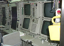
Sperry Marine, a unit of Northrop Grumman, has developed a wide range of navigation systems for use on board naval vessels and, to date, has installed in excess of 325 integrated bridge systems worldwide. Ships that have equipped military integrated navigation bridge systems (INBS) include US CV, CVN and LHD ship classes as well as ice breakers and various other international naval vessels.
Replacing traditional, paper-based marine navigation several years ago, Sperry Marine’s INBS offers automated collection, processing, control and display of vital navigation sensor data.
How well do you really know your competitors?
Access the most comprehensive Company Profiles on the market, powered by GlobalData. Save hours of research. Gain competitive edge.

Thank you!
Your download email will arrive shortly
Not ready to buy yet? Download a free sample
We are confident about the unique quality of our Company Profiles. However, we want you to make the most beneficial decision for your business, so we offer a free sample that you can download by submitting the below form
By GlobalDataThis approach maximises bridge watch efficiency and ship control safety, while offering several other benefits. The voyage management system (VMS) is a computer-based navigation, planning and monitoring system that provides the necessary tools to navigate voyages electronically and meets the US Navy’s electronic chart display and information system – navy (ECDIS-N) requirements.
See Also:
The automated radar plotting aid (ARPA) system automatically acquires and tracks contacts, providing accurate information to the watch team, while the ship control system (SCS) provides command and control signals to ship propulsion systems.
The MIBS installed aboard naval vessels forms a core component of the US Navy’s SmartShip programme, which aims to adopt commercial technology solutions to reduce manning and operating costs of the fleet.
Most recently, Sperry Marine signed a full production contract to supply its INBS to the UK Ministry of Defence for use aboard the Queen Elizabeth Class aircraft carriers, with Sperry Marine vice president J Nolasco DeCunha citing the ‘critical importance of the new aircraft carriers for the defence posture of the UK’.
Acoustic positioning and inertial navigation
IxSEA’s global acoustic positioning system (GAPS) is a pre-calibrated underwater system that is capable of tracking targets with high accuracy in difficult environments, even in both deep and shallow waters.
With a maximum depth of 4,000m, the system works by combining ultra short base line (USBL), GPS and inertial navigation technologies to track subsea vehicles such as sonar towed systems, autonomous unmanned vehicles (AUV) or mine killers, as well as locating the position of divers.
Based on fibre-optic technology, IxSEA’s photonic inertial navigation system (PHINS) outputs a vessel’s position, attitude and velocity data to extreme levels of accuracy.
The system is lightweight, compact and requires little maintenance, making it a cost efficient navigational system option for naval vessels.
By incorporating a sophisticated Kalman filter, the system is ideal for use aboard surface naval vessels such as frigates and patrol boats, whereas the company’s MARINS alternative is more suitable for use aboard submarines, frigates and aircraft carriers given its weapon stabilisation capability. The MARINS system is based upon fibre-optic gyroscope (FOG) technology and was specifically designed to meet the naval demand for increased accuracy and reliability.
Complimenting these technologies, IxSea has also developed a fibre-optic technology-based strapdown gyrocompass, entitled OCTANS, that boasts a complete all-axis motion sensor that is capable of reading true heading, roll, pitch, surge, sway, heave, speed and acceleration data for use aboard fast patrol boats and coastguards. IMO certified, the system is ‘maintenance free’ due to there being no spinning element and can be connected via Ethernet, bluetooth of Wi-Fi.
IxSEA MARINS systems were chosen by Abu Dhabi Systems Integration on behalf of the UEA Navy for use aboard the Ghannatha Class missile boats in October 2010. Ghannatha CSI programme manager Oscar Correa said, “We chose IXSEA because its navigation systems are very precise and provide operators with a complete set of data.”
Collaborated navigational efforts
Astronautics and Kearfott have collaborated to develop the Kearfott ship integrated navigation system (SINS) which comprises highly efficient components and a complete software configuration to provide naval vessels with a complete navigation solution.
The SINS works with system sensors that provide navigation data to a Retransmission Unit (RTU), which acts as the hub of the system by collecting data and distributing it to the particular user that requires it. The RTU has been designed in such a way to combine and process all available information into a digital navigation master message (DNMM), while a high-rate data bus transmits the DNMM to displays, alarms and ship systems. Attitude data is also collated from a ship’s INSs and processed by the RTU, providing high-accuracy analogue synchro data outputs.
System control is managed through individual control / display units as well as the RTU, with major subsystems operated by their own displays. The design of the system also enables control to be performed through a centralised combat control system, while a master navigation digital message is retransmitted to various display units across the vessel.
Included within the navigation system is a back-up provision that combines two high-accuracy INSs that remain redundant while the SINS is active.